- 829 Posts
- 273 Comments
Joined 1 year ago
Cake day: June 24th, 2023
You are not logged in. If you use a Fediverse account that is able to follow users, you can follow this user.

 5·4 days ago
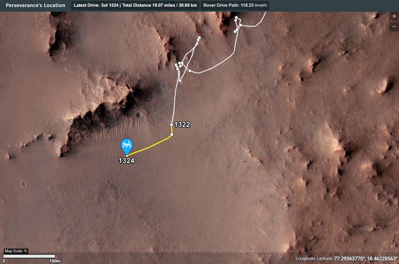
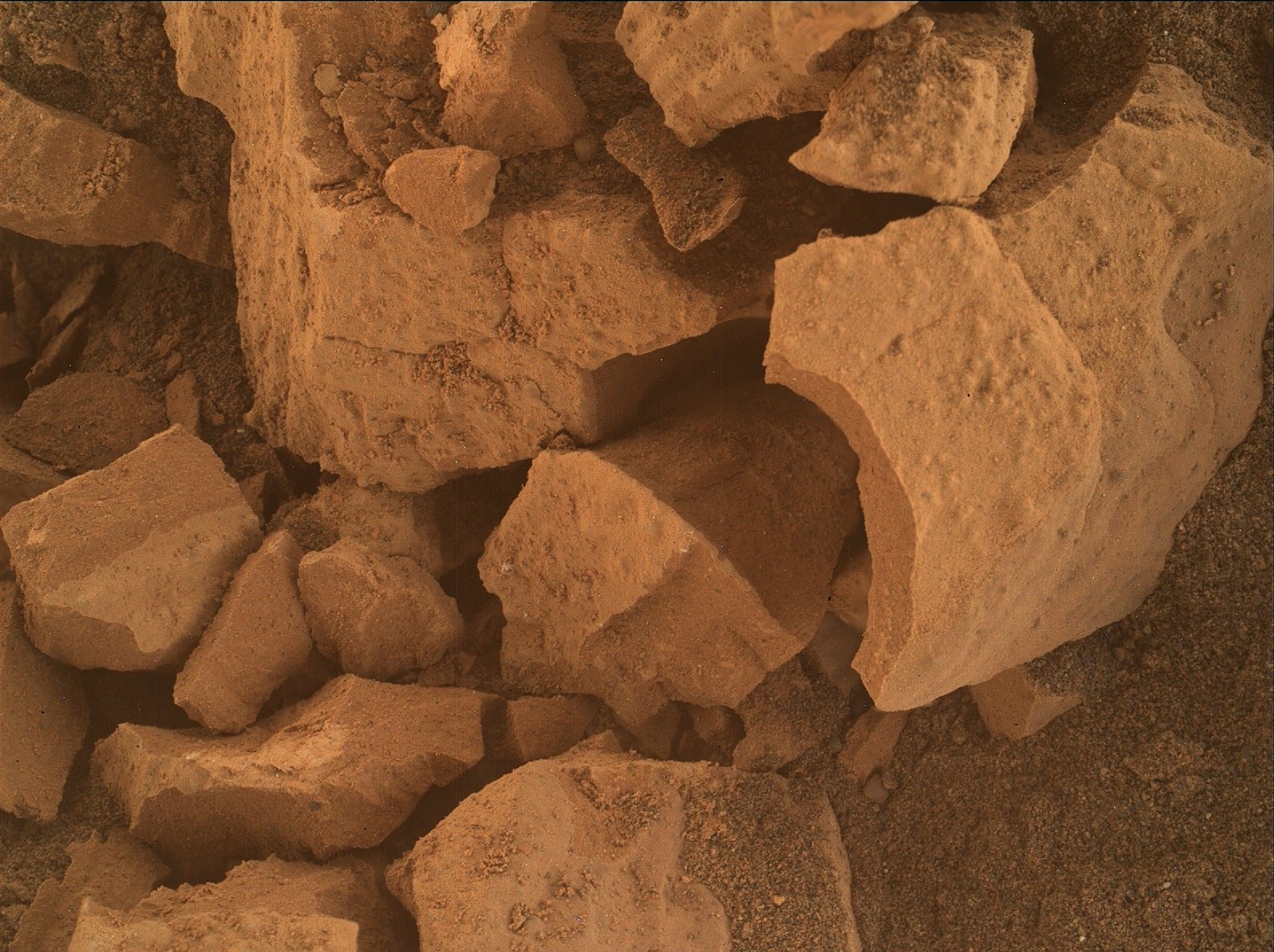
The imaging chamber was empty, but it captured some out of focus pebbles on the ground under the cache storage area (I assembled all 16 tiles) they first took a 16 tile image of the empty chamber back on sol 88. I assume that was an engineering checkout of the the camera.
I have an unusual guess as to why they imaged it. Not sure if you noticed, but there are motes of dust on the NavCam lenses, the motes are particularly noticeable in the all-sky images from sol 1323. I’m assuming that could have been the result of a dust devil, or we are in a particularly dusty area kicked up by the prevailing wind? Not sure if you also noticed we can no longer see the far rim wall of Jezero (due to recent increasing dust levels) If we’ve noticed, the team will have noticed as well, so they may have imaged the open chamber of the CacheCam to see if there is any dust on the mirror it uses, or the CacheCam camera lens. Maybe a little far fetched, but I often have an over active mind :)
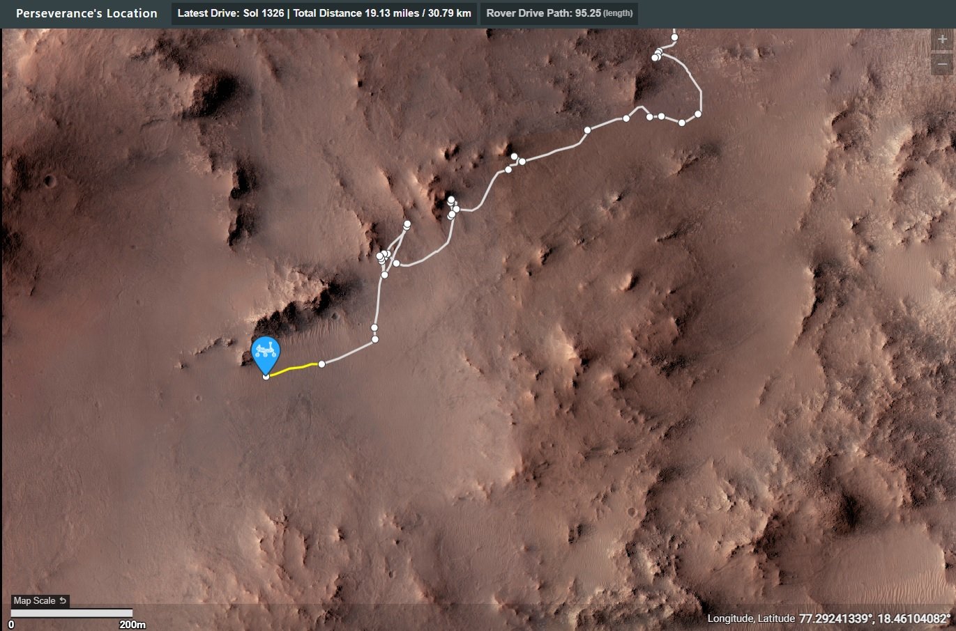
The rover has just driven South (a short distance on 1324) and it is currently pointing East. It could be an intermediate waypoint in a longer drive, but why East? Expand my theory to moving the cameras away from the prevailing wind :) (active mind LOL)
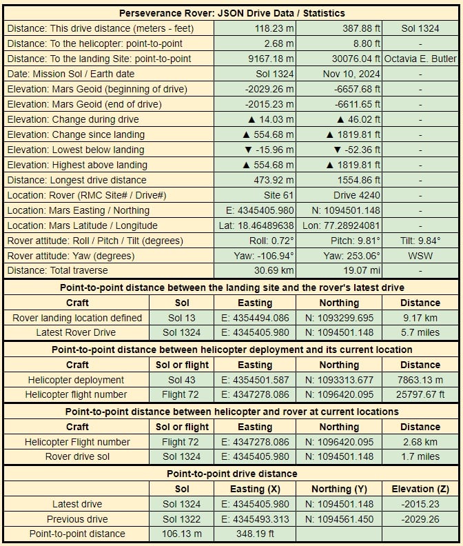
EDIT The sol 1324 waypoint mentioned earlier was an intermediate waypoint, the remainder of the drive was to the West. Close to 100 meters and a climb of ~25 meters. Waiting for the formal data, will share ASAP
 2·7 days ago
I wish you faster speeds in the future, it holds some wonderous images and data. Take care :)
Milly’s Foot Path
The rover is in a map quadrangle called ‘Bishop’, so all targets are named after Bishop in Owens Valley (California)
Milly’s Foot Path is a path through a rugged chute full of broken rocks . See image on https://www.flickr.com/photos/psa104/15269986920
I guess a member of the MS team may have ventured up that path at some time in the past…
“A Climber’s Guide to the High Sierra” page 221 gives a fair account of the passes and identifies their namesakes as Lucy Brown, wife of Bolton Coit Brown who crossed the divide in 1896. Milly’s is named for Mildred Jentsch who with Sylvia Kershaw crossed the saddle just north of Mt. Genevra in July 1953.
Here’s how they assign names based on map quadrangles…
Before touching down in Gale crater Curiosity’s landing ellipse and the foothills of Aeolis Mons (Mt. Sharp) were divided up into 151 map quadrangles to aid geological mapping. Each of these square areas of interest spans 0.025 degrees in latitude by 0.025 degrees in longitude, each quadrangle measures about 1.5 kilometers square or about 1.22 x 1.22 km. Each quadrangle is assigned a name of a town with a population less than 100,000 people.
Map quadrangles are usually named after towns close to notable regions of geological interest on Earth, its name then provides the source of the target names within each quadrangle.
List of Quadrangles the rover has visited:-
Yellowknife: Quadrangle #51: Yellowknife a city in northwestern Canada as well as group of rocks from the same region. The rocks were formed 2.7 billion years ago from both volcanoes and sediments laid down by water, and were deposited over 4-billion-year-old rocks, the oldest known on Earth.
Mawson: Quadrangle #65: Mawson, Antarctica, permanent base and research outpost in Antarctica, named after the Antarctic geologist and explorer Sir Douglas Mawson.
Coeymans: Quadrangle #64. Takes its name from the town of Coeymans in upstate New York, located near the fossil‐rich Coeymans Limestone Formation.
Kimberley: Quadrangle #78. Takes its name from the northernmost region of Western Australia, the site of many important geologic investigations of Precambrian rocks.
Hanover: Quadrangle #77, Takes its names from a New Hampshire city.
Shoshone: Quadrangle #91. Takes its name from Shoshone Village in Inyo County, California located just outside Death Valley National Park and the Nopah Range Wilderness Area.
Arlee: Quadrangle #90. Takes is name from after a geological district in Montana
Windhoek: Quadrangle #104. Takes its name from a geological district in Namibia.
Bar Harbor: Quadrangle #118 Takes its name from Bar Harbor, Maine
Kuruman: Quadrangle #132. This quadrangle is named after a charming town situated on the edge of the Kalahari desert in South Africa. Notably, the town of Kuruman is the namesake for the Kuruman Iron Formation, a ~2.46 billion year sedimentary rock that is rich in hematite. Hematite is the same mineral we can see is distributed throughout the Vera Rubin Ridge from orbital data! The target names in this quadrangle are pulled from famous geological features from South Africa and nearby Botswana and Zimbabwe.
Biwabik: Quadrangle #119, the Biwabik name was selected because of the city’s connection with the Mesabi Range, which contains large deposits of Precambrian iron ore.
Torridon: Quadrangle #133, Named after a village in the Northwest Highlands of Scotland, which is near an important geological formation called the Torridonian Supergroup. Therefore, all of the names assigned to targets in this region of Curiosity’s traverse come from landforms, geologic formations, and towns in that part of Scotland.
Nontron: Quadrangle #134, ‘Nontron’ is named after a commune in the Dordogne in southwestern France. The Nontron quadrant name is particularly appropriate for the clay-bearing terrain we find ourselves in as Nontron is the type locality for a clay mineral called nontronite. Nontronite is part of the smectite group of clays, which are the most common types of clays on Mars.
Roraima: Quadrangle #147. The Roraima quadrant is named after the northern-most state of Brazil and Mount Roraima, which is the highest peak in the Pakaraima mountains which sits between Brazil, Venezuela, and Guyana. The terrain in the Roraima region on Earth looks somewhat similar to the area Curiosity is in - with flat-topped hills and some steep slopes.
Kalavryta: Quadrangle #148 Kalavryta is named after a town in Greece, due west of Athens and near the Chelmos-Vouraikos UNESCO Global Geopark, a region that consists of 40 unique geological sites including caves, karstic springs, rivers, alpine lakes, and fossil sites.
Bishop: (Current Quadrangle) Bishop California is located in Owens Valley, and is the starting point for trips into the High Sierra, including some awesome geology. It feels like a fitting name for this part of Curiosity’s ascent of Mt. Sharp!
I wish they would release this sort of update more frequently :)
I hope the agencies that govern the space fairing nations continue to fund exploration to further our understanding of our solar system and beyond
What have they done with Ken
I heard reports of persistent banging on a locked storage room door at JPL, but strangely no one could find the key ;)
Can mean a lot of things, sometimes they could be metamorphic rocks. Basically they are interesting because this rover has not conducted any contact science on a white rock since arriving in Jezero crater. Only once they’ve completed an investigation will we know what type it is
His video titles are often clickbait, but on the whole I enjoy his content.
ICYMI - They just drove downslope to a field full of small white (light toned) rocks :)
I’ve not had the pleasure of visiting any of those analog locations, but I have thoroughly enjoyed visiting a few of the remote deserts in the middle East in my working years. Granted I was there for work, but did get to explore / enjoy the places during downtime :) I’m with you regarding the need to be sure of the environment before we put boots on the Martian surface, but that could have been done years ago, even decades ago. The 60’s was an amazing time to witness what was being achieved. Hopefully there will be a similar period in the future. Time will tell.
Are we really passing up all those tasty-textured boulders on the hill??
It’s certainly looking that way. I’ve wanted boots on the ground since the Apollo missions were completed. Certainly not going to happen in what’s left before they nail down my pine lid. That’s for the younger one’s to experience…
It looks like it has been polished by eons of wind blown dust particles
Nicely done, I preferred the older JPL mission traverse maps as used on the early years of the MSL mission, as each waypoint and some of the larger features were labeled. I can only assume that the new style interactive maps can not cope with that level of detail.
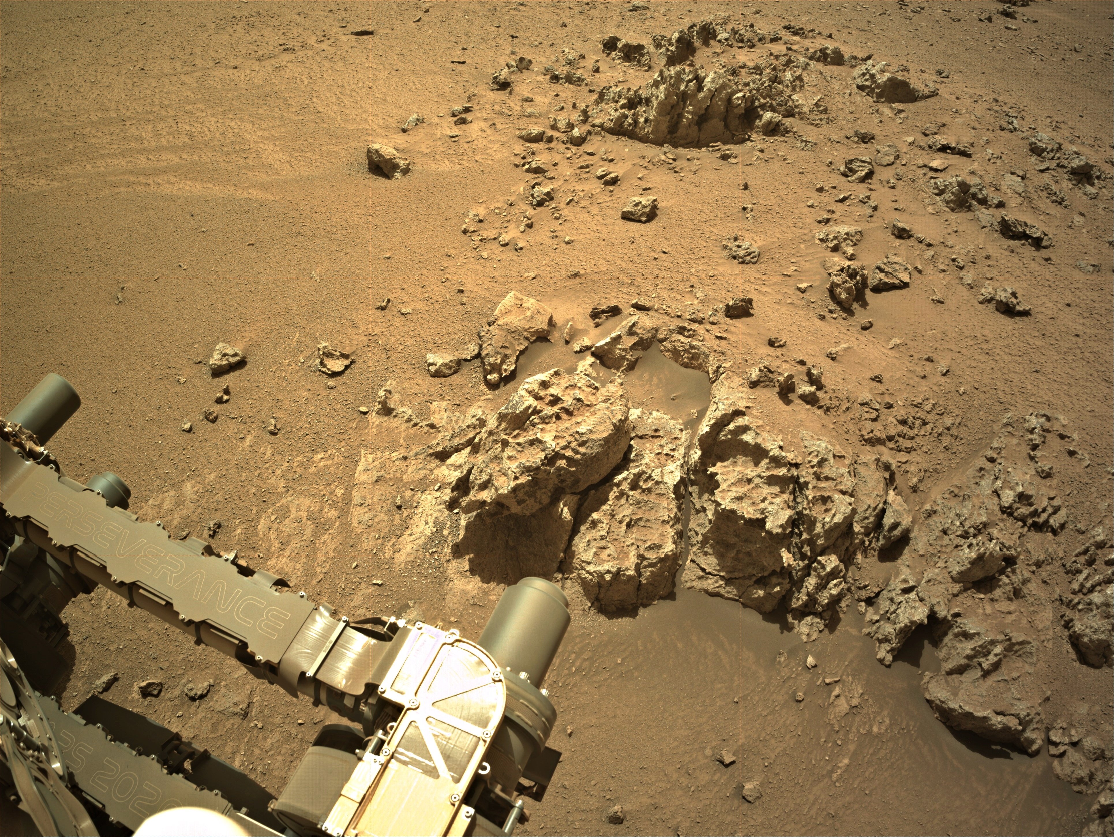
Look close - You’ll see one of the rear wheels perched on a rock.
They will likely not perform any arm work in this state.
Apologies for the stitching errors (upper right of the slope) MS-ICE didn’t do a great job this time, and I missed it before sharing
You mean “notional path to the SSW”, Paul, no?
They chose North on 1301 :) see https://mars.nasa.gov/maps/location/?mission=M20
Not quite the place I was thinking of, but we have a good selection of targets for arm work :)
My bad, SSW… Fat fingers 😮
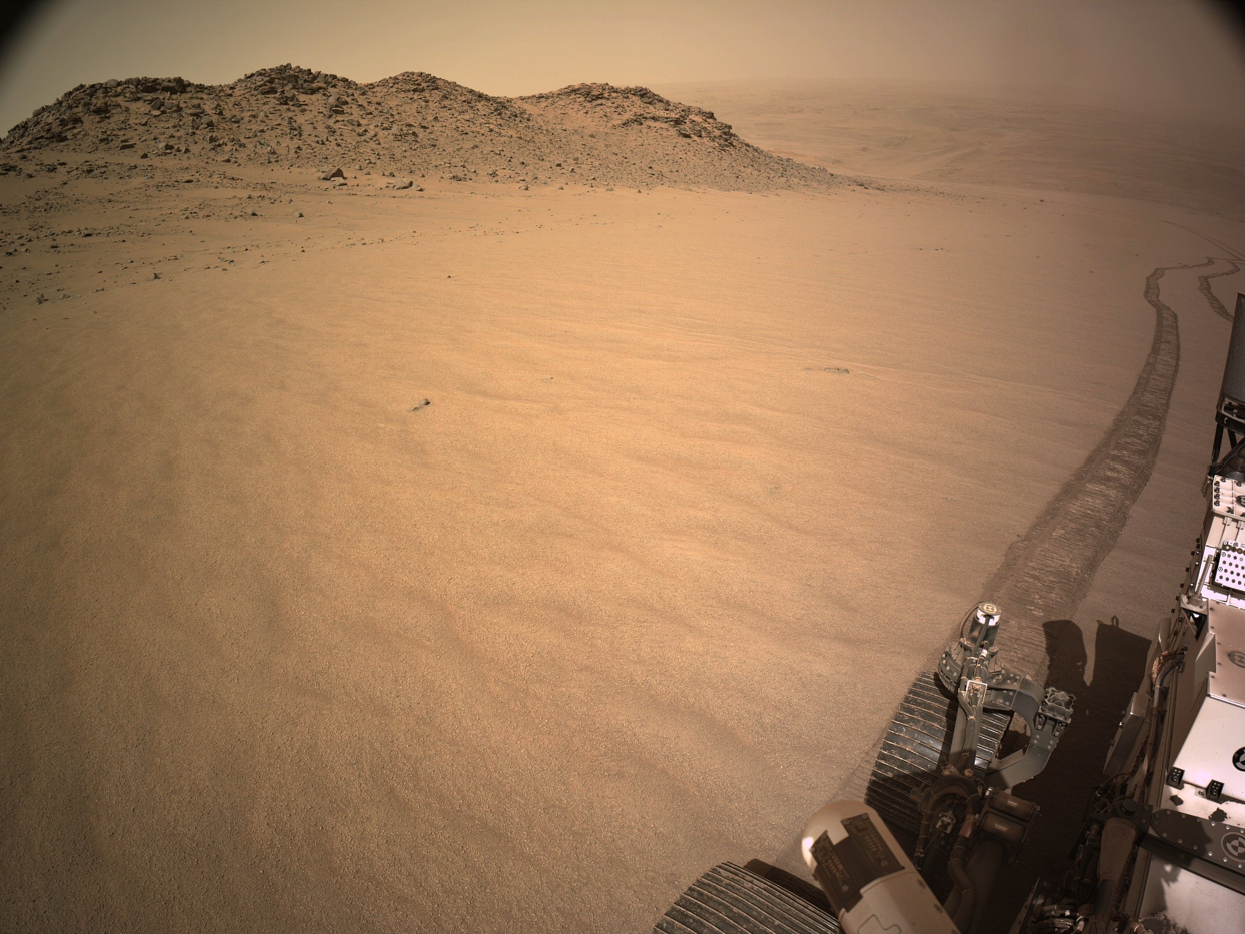
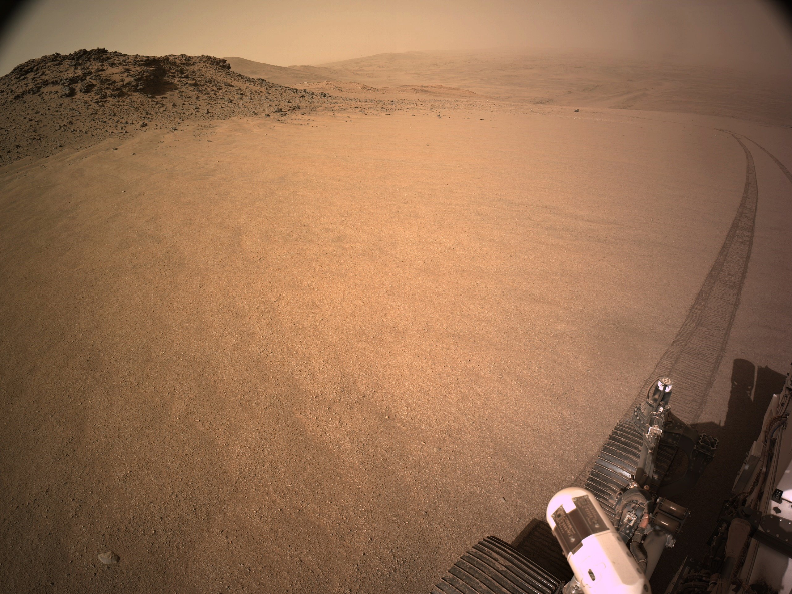
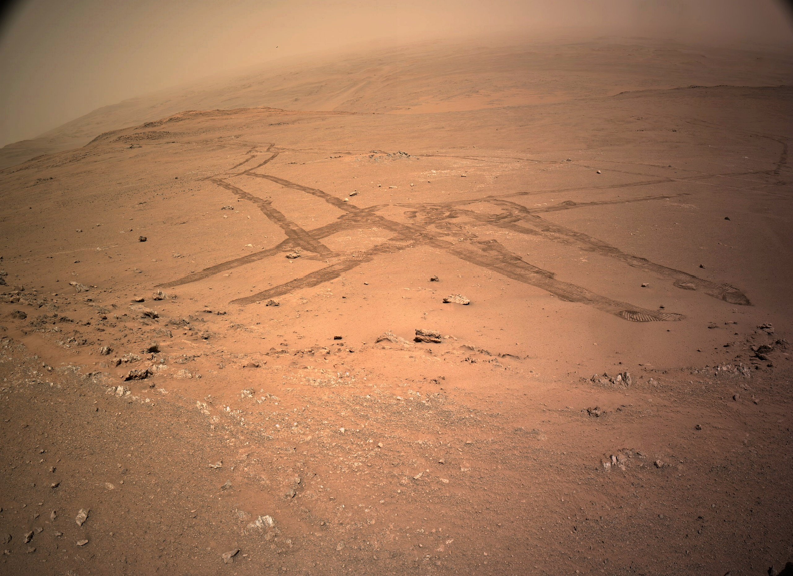
This is a 4-tile end-of-drive NavCam. The rear of the rover is pointing NE. Assembled in MS-ICE - Credits: NASA/JPL-Caltech
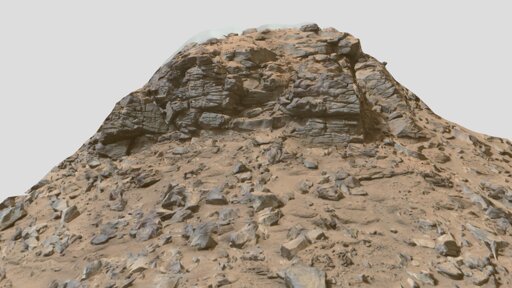
The rover is currently driving up the rim wall of Jezero crater. The rim wall was created by a huge impact in Mars early history. So we could be looking at some of the oldest rocks that were uplifted during the impact. I’m clearly not a geologist, so it will be interesting to see the results of the investigations of the rocks in this region by the science team.
Unless it was a significant amount of dust on the camera lens or the mirror that it uses to look down into the imaging chamber I doubt that it would affect operations at all, as they only use the camera to ensure the sample is still in the tube prior to sealing it. But why else image it without a tube, it appears to be a waste of bandwidth as they acquired and then downlinked 20 tiles in all from the CacheCam. Hopefully the team will enlighten us soon why it was imaged, if not we can wait for the mission managers report in the PDS, those reports of often goldmines of information. The report covering sol 1324 activities should be available in the M2020 PDS (release number 12) scheduled to be issued on April 3, 2025 https://pds-geosciences.wustl.edu/missions/mars2020/index.htm