fossilesqueMEnglish · 4 months agoOldMapsOnlineplus-squarepinwww.oldmapsonline.orgexternal-linkmessage-square1fedilinkarrow-up117arrow-down11
arrow-up116arrow-down1external-linkOldMapsOnlineplus-squarepinwww.oldmapsonline.orgfossilesqueMEnglish · 4 months agomessage-square1fedilink
fossilesqueMEnglish · 2 years agoMods wanted!plus-squarepinmessage-squaremessage-square2fedilinkarrow-up17arrow-down10
arrow-up17arrow-down1message-squareMods wanted!plus-squarepinfossilesqueMEnglish · 2 years agomessage-square2fedilink
fossilesqueMEnglish · edit-221 days ago[National Geographic] Egypt - Nile Valley, Land of the Pharaohs (1965)plus-squareimagemessage-square0fedilinkarrow-up110arrow-down10
arrow-up110arrow-down1image[National Geographic] Egypt - Nile Valley, Land of the Pharaohs (1965)plus-squarefossilesqueMEnglish · edit-221 days agomessage-square0fedilink
fossilesqueMEnglish · 21 days ago[National Geographic] China (1945)imagemessage-square0fedilinkarrow-up18arrow-down10
arrow-up18arrow-down1image[National Geographic] China (1945)fossilesqueMEnglish · 21 days agomessage-square0fedilink
fossilesqueMEnglish · 21 days ago1587 map of Japan by Urbano Monte. Created after Japanese diplomats visited Milan in 1582.plus-squareimagemessage-square1fedilinkarrow-up112arrow-down10
arrow-up112arrow-down1image1587 map of Japan by Urbano Monte. Created after Japanese diplomats visited Milan in 1582.plus-squarefossilesqueMEnglish · 21 days agomessage-square1fedilink
fossilesqueMEnglish · 21 days agoForeign-Born Population of the United States, 1900plus-squareimagemessage-square0fedilinkarrow-up118arrow-down10
arrow-up118arrow-down1imageForeign-Born Population of the United States, 1900plus-squarefossilesqueMEnglish · 21 days agomessage-square0fedilink
fossilesqueMEnglish · 22 days ago[National Geographic] The Moon (1969)imagemessage-square0fedilinkarrow-up123arrow-down10
arrow-up123arrow-down1image[National Geographic] The Moon (1969)fossilesqueMEnglish · 22 days agomessage-square0fedilink
fossilesqueMEnglish · 22 days ago[National Geographic] South America (1921)imagemessage-square3fedilinkarrow-up119arrow-down10
arrow-up119arrow-down1image[National Geographic] South America (1921)fossilesqueMEnglish · 22 days agomessage-square3fedilink
fossilesqueMEnglish · 24 days ago[National Geographic] World Ocean Floor (1981)imagemessage-square8fedilinkarrow-up138arrow-down10
arrow-up138arrow-down1image[National Geographic] World Ocean Floor (1981)fossilesqueMEnglish · 24 days agomessage-square8fedilink
fossilesqueMEnglish · 24 days ago[National Geographic] The Southwestern United States (1940)imagemessage-square2fedilinkarrow-up111arrow-down10
arrow-up111arrow-down1image[National Geographic] The Southwestern United States (1940)fossilesqueMEnglish · 24 days agomessage-square2fedilink
fossilesqueMEnglish · 24 days ago[National Geographic] The Middle East: Two Centuries of Conflict (1980)imagemessage-square0fedilinkarrow-up15arrow-down11
arrow-up14arrow-down1image[National Geographic] The Middle East: Two Centuries of Conflict (1980)fossilesqueMEnglish · 24 days agomessage-square0fedilink
fossilesqueMEnglish · 24 days ago🇲🇽 Remember, Remember 🇲🇽imagemessage-square16fedilinkarrow-up1461arrow-down16
arrow-up1455arrow-down1image🇲🇽 Remember, Remember 🇲🇽fossilesqueMEnglish · 24 days agomessage-square16fedilink
fossilesqueMEnglish · 24 days agoMaps of The Valley of Mexico and Texcoco from the Codex Xolotl (1542) (more in post body)plus-squareimagemessage-square2fedilinkarrow-up129arrow-down10
arrow-up129arrow-down1imageMaps of The Valley of Mexico and Texcoco from the Codex Xolotl (1542) (more in post body)plus-squarefossilesqueMEnglish · 24 days agomessage-square2fedilink
fossilesqueMEnglish · 1 month agoNational Geographic - Ethnolinguistic Map of the Peoples of Africa (1972)imagemessage-square8fedilinkarrow-up113arrow-down11
arrow-up112arrow-down1imageNational Geographic - Ethnolinguistic Map of the Peoples of Africa (1972)fossilesqueMEnglish · 1 month agomessage-square8fedilink
fossilesqueMEnglish · 1 month agoTenochtitlán, Later Mexico City: View from 1617imagemessage-square7fedilinkarrow-up1103arrow-down10
arrow-up1103arrow-down1imageTenochtitlán, Later Mexico City: View from 1617fossilesqueMEnglish · 1 month agomessage-square7fedilink
fossilesqueMEnglish · 1 month agoNational Geographic - Jerusalem (1996)imagemessage-square1fedilinkarrow-up16arrow-down10
arrow-up16arrow-down1imageNational Geographic - Jerusalem (1996)fossilesqueMEnglish · 1 month agomessage-square1fedilink
fossilesqueMEnglish · 1 month agoNational Geographic - Where did Colombus discover America? (1987)imagemessage-square1fedilinkarrow-up112arrow-down10
arrow-up112arrow-down1imageNational Geographic - Where did Colombus discover America? (1987)fossilesqueMEnglish · 1 month agomessage-square1fedilink
fossilesqueMEnglish · 1 month agoNational Geographic - Antarctic Regions (1932)imagemessage-square0fedilinkarrow-up14arrow-down10
arrow-up14arrow-down1imageNational Geographic - Antarctic Regions (1932)fossilesqueMEnglish · 1 month agomessage-square0fedilink
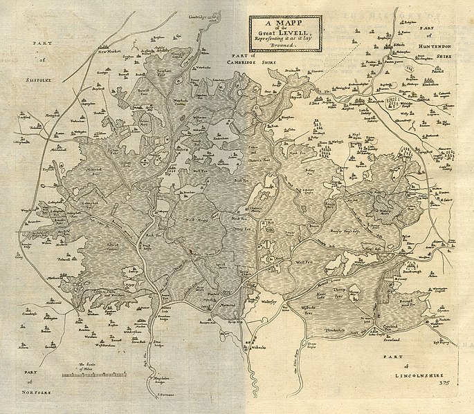
fossilesqueMEnglish · 1 month agoThe Fens, UK: "A Map of the Great Levell, representing it as it lay drowned." (1662) & "The Map of the Great Levell drained" (1662; see post)plus-squareimagemessage-square0fedilinkarrow-up19arrow-down10
arrow-up19arrow-down1imageThe Fens, UK: "A Map of the Great Levell, representing it as it lay drowned." (1662) & "The Map of the Great Levell drained" (1662; see post)plus-squarefossilesqueMEnglish · 1 month agomessage-square0fedilink
fossilesqueMEnglish · 1 month agoThe Gough Map (1370)plus-squareimagemessage-square10fedilinkarrow-up129arrow-down10
arrow-up129arrow-down1imageThe Gough Map (1370)plus-squarefossilesqueMEnglish · 1 month agomessage-square10fedilink