
You must log in or register to comment.
The border between Paraná and Santa Catarina (1921 name: Santa Catharina) is wrong for the date. The current border was defined in 1916, in the Contestado War:
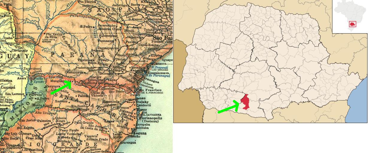
The city I arrowed in both maps is the same (Mangueirinha), note how the map in the OP assigns it to Santa Catarina.
The borders would be accurate for pre-1916 times if the map didn’t automatically assign the contested region solely to Santa Catarina:

Climate map is also slightly incorrect for Paraná; there should be a yellow blob around Curitiba (1921 name: Curityba), as the historical average is 17.8°C, or 64°F. The reason for that can be seen in the physical map, it’s in the middle of a rather tall plateau.
The city called “Iguassu” (near the Paraguayan border) had its name changed already back in 1918, to the contemporary Foz do Iguaçu.
The Paraguayan city labelled “Azara” is not Azara at all; it’s Ciudad del Este (1921 name: Puerto Presidente Stroessner). Azara is up south, in Misiones (Argentina), bordering Corrientes.
The Paraguayan-Bolivian border seems accurate for the time though, as this would’ve happened before the Chaco War (1932-5). Eventually that disputed territory would end mostly under Paraguayan control, with Paraguay relinquishing the claims to the small strip left under Bolivian control.
Sorry for the oddly specific corrections. I know that it’s an old map, being posted for the sake of curiosity; and that by then info was rather slow to go back and forth, so a lot of those errors are understandable. Still… I need to sperg out about my homeland at least once in a while :3
John Mary the Monk is coming. He’ll lead us to the Celestial Monarchy.I wonder if they used some out of date references…
Most likely. And to be fair they wouldn’t be even that out-of-date; most of those changes would be rather recent when the map was made, and the Contestado War was extremely confusing for outsiders, so I kind of get why they’d assign it to Santa Catarina.
Still. Seeing those old names gave me feels. Thank you for sharing this!

![[National Geographic] South America (1921)](https://mander.xyz/pictrs/image/4eb68792-4896-47e1-96a0-f4480cc7c2b7.jpeg)